Obiective
Obiectivul general al proiectului il reprezinta cuantificarea si predictia dispersiei aerosolilor rezultati in urma arderilor de biomasa (BBA), din surse naturale si antropice, peste Romania si impactul acestora asupra calitatii aerului si al climei. Scopul proiectului este de a exploata capacitatile complementare oferite de monitoare in situ, teledetectie, date satelitare si platforme aeriene, pentru a imbunatati predictia de dispersie la scara larga a emisiilor de aerosoli. Acesta isi propune sa investigheze sursele potentiale si proprietatile BBA, pene de fum urban si antropogen. Punctul de start il reprezinta un studiu de caz de cercetare in zona Bucuresti. Pentru asi atinge scopul, proiectul trebuie sa indeplineasca urmatoarele obiective:
- Sa cuantifice proprietatile aerosolilor rezultati din arderea biomasei din sistemele naturale si antropice din Romania
- Sa identifice caile de transport si procesele de modificare ale aerosolilor rezultati din arderea biomasei (antropici si naturali), in regiune
- Sa realizeze predictia aerosolilor rezultati din arderea biomasei, precum si impactul acestora asupra calitatii aerului si al climei la nivel local si national
Prezentare
Proiectului MOBBE, Model Computational pentru Predictia Emisiilor de “Biomass Burning”, investigheaza sursele potentiale si proprietatile aerosolilor din arderea biomasei peste Romania prin efectuarea unui studiu in zona Bucuresti, folosind algoritmi de inversie imbunatatiti. Rezultatele (o noua parametrizare a proceselor fizice a aerosolilor din arderea biomasei, surse si proprietati) sunt implementate in modelulde dispersie FLEXPART, bazat pe mecanismul Lagrangean de dispersie a particulelor. Modelul foloseste datele meteorologice furnizate de COSMO (Consortium for Small-scale Modeling). Emisiile din arderea biomasei sunt comparate cu analiza zilnica a coeficientului de absorbtie optica a particulelor fine (AOD) la 550 nm, oferite de radiospectrometrul MODIS lansat de NASA pe satelitii Aqua si Terra, cu produsele MAAC II precum si cu un set de date independent de AOD furnizate de AERONET. Toate aceste informatii sunt integrate in „Instrumentul Web MOBBE”. Proiectul de cercetare MOBBE este o infrastructura interdisciplinara de cercetare a mediului bazata pe masuratori continue, doua campanii experimentale intensive (vara si iarna) si opt ore de zbor ale unei aeronave de cercetare, integrand monitoare in-situ, observatii de la sol si aeriene cu o analiza detaliata a datelor satelitare si a rezultatelor modelarii numerice. Datele satelitare sunt furnizate de instrumentele MODIS de pe satelitii Terra si Aqua, de lidarul Caliop de pe satelitul CALIPSO si de EUMETCast.
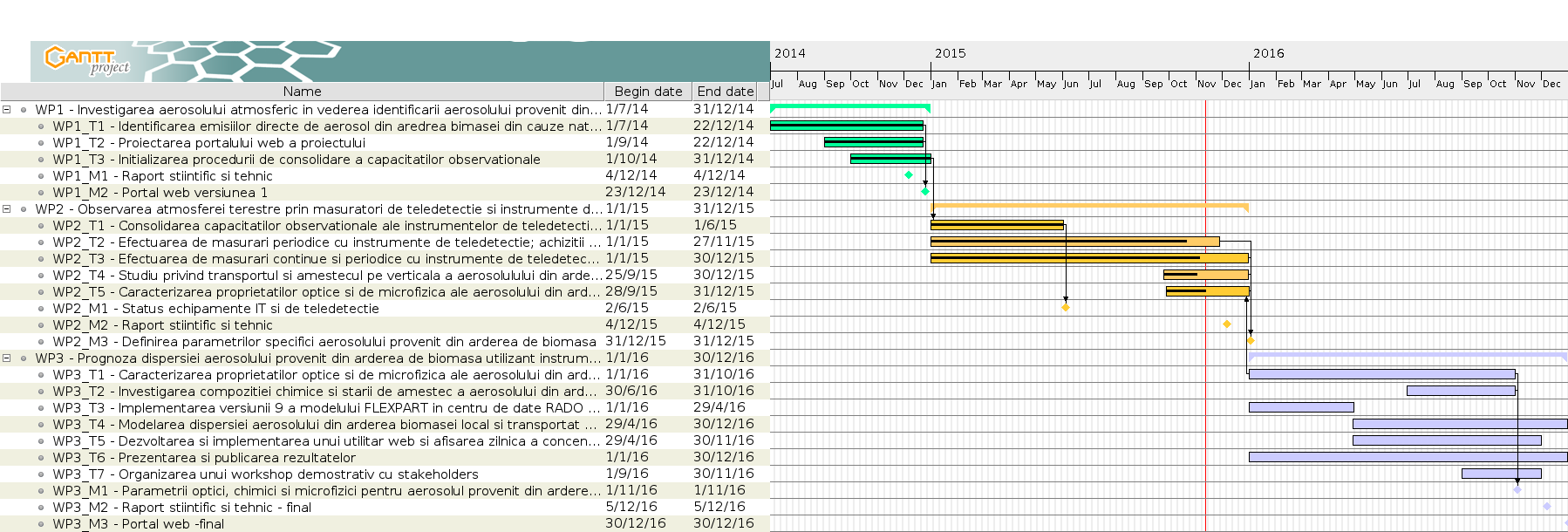
Program
| M1. Investigare | Iul.- Dec. 2014 |
| M2. Observare si Analiza | Ian.- Dec. 2015 |
| M3. Prognoza | Ian.- Dec. 2016 |
Diagrama Gantt a priectului MOBBE, faceti click pentru o versiune marita
Objectives
General objective: quantify and predict natural and anthropogenic BBA dispersion over Romania and its impact on air quality and the climate.
The project purpose is to exploit the complementary capabilities offered by in situ monitors, remote sensing, satellite and airborne data in order to improve the large-scale dispersion forecasts of emitted compound. It aims to investigate the potential sources and the properties of BBA and the urban and anthropogenic smoke plumes over Romania, starting as a research case study in the Bucharest area. The project must:
- Quantify the properties of biomass-burning aerosols from natural and anthropogenic sources in Romania
- Identify the transport pathways and modification processes of biomass burning aerosols (anthropogenic and natural) in the region
- Predict biomass burning aerosols, and their impact on air quality and climate at local and national scale
- Increase scientific visibility
Overview
MOBBE, Computational Model for “Biomass Burning” prediction and their Impact – aims to investigate the potential sources and the properties of aerosols from biomass burning, urban aerosols and long-range transport aerosols over Romania, performing a first research case study in the Bucharest area, using improved inversion algorithms. The results (a new parametrization scheme of the physical processes of the biomass burning aerosols, sources and properties) will be implemented during the project, in the FLEXPART aerosol dispersion model based on the Lagrangean particle dispersion mechanism. As meteorological input data, the model will use new data from COSMO (Consortium for Small-scale Modeling) model. Anthropogenic and natural emissions of biomass burning will be compared with the daily analysis and the fine mode aerosol optical depth (AOD) at 550 nm provided by the radio-spectrometer MODIS launched by NASA on the Aqua and Terra satellites, MAAC II, and with an independent dataset of AOD from the AERONET network. All the above information will be integrated in a “MOBBE Web Tool”.
The MOBBE research project is an interdisciplinary environmental research infrastructure based on continuous measurements, two intensive experimental field campaigns (summer and winter campaign) and eight flight hours of a research aircraft, that integrates in-situ monitors, ground-based and airborne observations, with a detailed analysis of satellite data and numerical modeling results. The satellite data are provided by the MODIS instruments from the satellites Terra and Aqua, by the Caliop lidar from the satellite CALIPSO and by EUMETCast.
Schedule
| M1. Investigation | Jul.- Dec. 2014 |
| M2. Observation and Analysis | Jan.- Dec. 2015 |
| M3. Forecast | Jan.- Dec. 2016 |
MOBBE Gantt diagrame, click for a larger version
[:]